|
006 Standing Stones, Sheriff Muir, Peebles. |
Prev |
Next |
Description
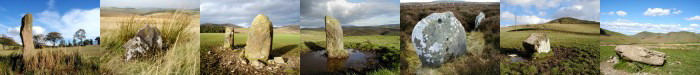
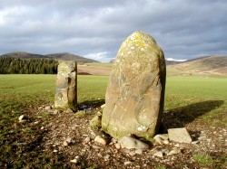
An open cultivated field about 4 miles west of Peebles, at Lyne
Station, forms the setting for two standing stones, set 2.10m
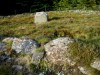
apart and each around 1.30m in height. There are other small
stones in the area between these two stones but these are
probably clearance stones from the surrounding field. No trace
can now be seen of a curved line of small boulders less than
0.30m high which once ran eastwards from the stones.
Directions
From Peebles take the A72 west towards Glasgow. After 4 miles turn
left onto a minor road leading to Lyne Station, cross the bridge
and head straight on pass some cottages and up the hill. The
stones can be seen in the cultivated field to the right. Pinkie's
Hole can be found in the Scot's Pine wood running along the south
side of the road.
Parking
Although the road is narrow it is relatively quite and vehicles
may be left by the road side. Please keep vehicles well into the
side to allow farm vehicles and other traffic to pass.
Folklore
There are two traditions associated with this site. One
suggests it to be the remains of a Druid temple with
Pinkie's Hole, a depression in the wood beside the road to
the south, being the sacristy where the sacrificial
procession was gathered. Pinkie's Hole and the two standing
stones are aligned in a north-south direction in line this
Pinkie's Hole. The other claims that the stones mark the
site of a fallen Border Chieftain and that Pinkie's Hole was
for those of lower status. It has been suggested that the
stones are the remains of a burial cairn but we shall
probably never know the true story. Pinkie's Hole in reality
is probably a gravel pit dating back to Roman times and is
one of many that can be seen in the area. It may have been
worked by the garrison at Happrew fort, about 200m to the
west.
Fieldnotes
Driving along the busy A72, this site is hidden from view from
the main road and only when you take a minor road through Lyne
Station can it be seen in the open field to the north. This mood
of this site changes with the weather and is at its best with
thunder clouds in the east and a low evening sun setting in the
west. However, best of all is a visit at night under a clear sky
when the stones glow faintly in the moonlight. You may also hear
the cry of a tawny owl in the wood to the south and, just
perhaps, witness a UFO buzzing around the Meldon Hills to the
north. But then again you might not!
|