| 035
Standing Stone, Drumelzier, Broughton. |
Prev |
Next |
Description
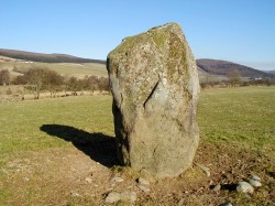
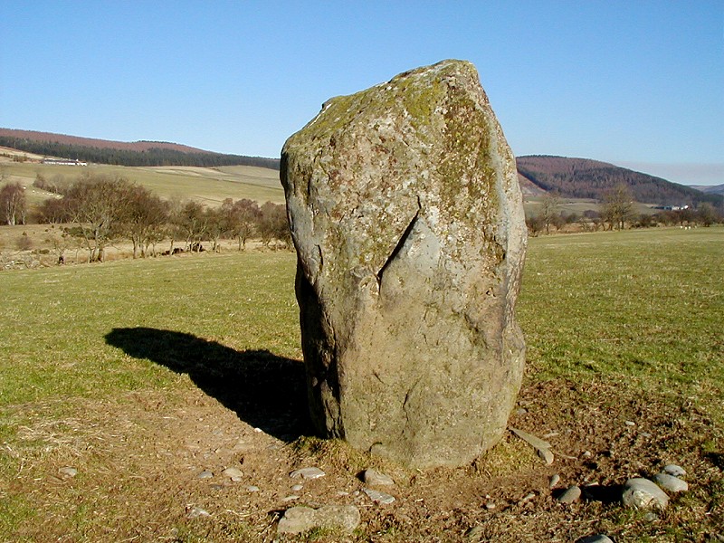
This substantial standing stone, situated on a slight elevation
beside the River Tweed, is wedge-shaped at the top and measures
1.65m high x 0.95m wide x 0.55m thick. The surrounding area is
low lying flood plain and prior to being drained, would be been
wet and boggy. This small area of raised ground would have
provided a prominent and secure location for the sighting of the
stone.
Directions
Drumelzier is on the B712 Peebles to Broughton road. The best way
to reach the stone is to follow the track beside the Drumelzier
Burn to the west of the village. Head for the river and follow the
bank downstream. A line of electricity pylons marks the field
containing the stone.
Parking
In Drumelzier village, beside bridge, outside village hall.
Folklore
There is no specific folklore directly associated with
this standing stone but according to legend which is at
least as old as the 15th century, the wizard Merlin was
buried 183m NNW of Drumelzier Church, on the level haugh
close to the right bank of the River Tweed. No structural
remains are now to be seen, or have ever been recorded, at
the place in question, but it is possible that the tradition
may have been originated from the discovery of a Bronze Age
cist in the area.
The following legend has also been found in connection with
this location. Merlin was converted to Christianity by St
Kentigern at the alter-stone a large block of rock opposite
Altarstone Farm in the parish of Stobo. The following day
Merlin met a strange three fold death, as he had already
prophesied. He was stoned by local shepherds, slipped down
the banks of the Tweed and impaled himself on stakes used to
secure fish traps. He drowned as the river unexpectantly
rose and his head fell below the water level.
Fieldnotes
Two points of interest were noted during a visit to this
standing stone on this occasion. One is that the main
"flat" axis of the stone is in a direct alignment with
the scant remains of the mediaeval Tinnis Castle, some 3/4 of a
mile to the south. The castle is constructed on an earlier Iron
Age hill fort. A possible alignment may exist in the
opposite direction taking in Trahenna Hill to a burial cairn on
Pyked Stane Hill, although this has not been checked on the
ground. The second point of interest is the possibility that
this stone marks a crossing point or ford along the River Tweed.
A similar stone exists at the Standing Stone in Cardrona,
Peebles where a ford is recorded and in use until recent times.
No ford has yet been located at Drumelzier although it is likely
to have existed.
Usually you can gleam some suggestions as to the purpose of a
standing stone, often by the proximity of other nearby
prehistoric structures. However, this stone poses a problem.
While there are other features on the surrounding area, none are
close by and the location would almost certainly have been
marshland or bog, forming the floodplain of the River Tweed. The
stone does stand on a slightly raised knoll of drier ground and
might have been used as an important place of worship or ritual.
Local legend connects the stone with the burial place of Merlin
and this ties in well with the possible but unrecorded discovery
of a Bronze Age cist. This site is proposed to be 183m NNW of
Drumelzier Kirk, over 1km from the stone.
Also of interest in the area is a stepping stone or style set
in the wall leading to the garden of Drumelzier Haugh farm. The
style is on an approximate line between the standing stone and
the high ground around the ruins of Tinnis Castle, itself
constructed on an Iron Age hill fort and settlement. Now, this
stone feature may be recent but does hint at the tradition of
not blocking the "fairy path", when superstitious
people where fearful of obstructing any pathway (ley?) that was
used by the Little People, to do so would bring bad luck. A
similar feature was found at Menzion, Tweedsmuir.
|
