| 063
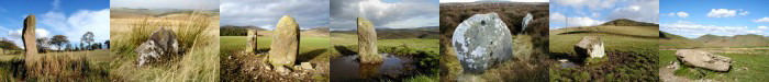
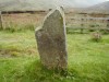
Stone Setting, Bught Rig, Yarrow. |
Prev |
Next |
Description
This stone setting on Bught Rig, comprises a group of sixteen
stones, eleven of which lie roughly on the circumference of a
circle about 14m in diameter. The largest stone still upright
stands to a height of 0.60m and there are only 3 other
stones visible, the remainder being overgrown with grass and
moss. In spite of this site's dilapidated condition, it is
possible to envisage this setting of stones as an ancient stone
circle, as has been claimed by other writers. The suggestion
that it is associated with a more recent, structure linked to
the nearby farm or croft does not seem likely.
Directions
Starting at Craig Douglas farm on the A708 Selkirk to Moffat road,
a mile or so west of the Gordon Arms. Proceed on foot, or better,
by mountain bike, along the dirt road signposted Public Footpath
to Peebles. Continue following the valley of the Douglas Burn for
5km, until the sheepfold below Bught Rig. Next, follow the
boundary fence up a "very" steep slope for approx 0.50km
until a boggy gully is crossed. After another 20 paces (look for
blue-rope marker on fence) head directly into the trees, keeping
to the same line that the trees follow. This should bring you to a
long clearing after less than 100m. The stones are at the south
west end.
Parking
There is space for careful parking at the track entrance beside
Craig Douglas farm, just off the A708.
Fieldnotes
Be warned, this is not an easy location to get to and actually
find when you get there. After a 5km hike along a hard-packed
trail, an arduous climb using both hands and feet up a very
steep hill and finally an exhausting thrash through 100m of
20 year old conifers and knee-deep peat bogs, you will finally
stumble upon this plain stone setting. I suppose it's nothing
fantastic but the sheer effort involved in getting there, gives
a great sense of achievement. A look at place-name meanings
behind Bught Rig does reveal some interesting possibilities.
"Bught is taken to be a house or hut for sheep, with
"Rig" meaning ridge.
There is a second stone setting known as the
"Douglas Stones" about 200m to the south east of the
above location. While this location is recorded by RCAHMS as
having been destroyed by forestry, four members of the Hawick
50+ Walking Group, namely Jennifer Payne, Margaret Smith, Wendy
Young and Anne-Marie have reported to me that the "Douglas
Stones" are alive and well. A site visit is planned for the
near future. My thanks to Jennifer and her gang of young lassies
for this information.
|
