|
Methods
Site
Design
Ancient Stones has been designed and is updated using
Microsoft Frontpage 2000 and has been kept simple and easy
to manage. The use of animation, JavaScript and other
similar techniques are avoided if possible. The only script
used on the site is that which manages the contact form. The
site is managed using templates whenever possible to keep
down the amount of work required. New pages and updates are
uploaded using WS FTP LE. I do not have any fixed schedule
for site updates but just upload pages as and when they are
ready.
Hosting
Ancient Stones is hosted under the 1&1 Business package
giving me 2.5 GB of web space, 20 GB monthly traffic and a
host of other features, all for less than �10.00 a month.
The package also offers the ability to run CGI scripts and
PHP, and also includes 700 POP3 email addresses. To date I
have had no problems at all and would strongly recommend
them to anyone. See www.oneandone.co.uk for further information and
up-to-date details.
Transport
Most site visits are by car, followed up by
walking or using a mountain bike where locations are some
distance from the nearest road.
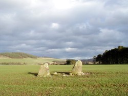
Field
Trips
On most occasions I will plan a field trip to take in around
5 or so sites, all located in the same general area or along
the same route. Each field trip will usually start around
7.00am
and will see me back home by tea time.
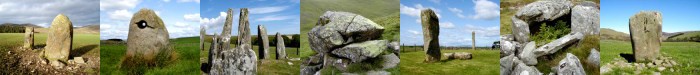
Photography
There is nothing fancy about the photographic equipment used
to record the pictures shown in Ancient Stones. My present
camera is a Pentax Option S5Z fitted with a 512MB SD media
card to store the images. Most images are taken using the
automatic exposure setting with a resolution set to 1280 x
960 pixels, more than large enough for web use. Occasionally
spot metering is used when lighting conditions are
difficult. A Canon EOS 300D digital SLR is also used
occasionally.
At
each site I will try and take as many different pictures as
I can, including close ups, distance shots and generally
trying to capture the overall setting where the stones are
located. On many occasions I have re-visited sites later to
try and obtain better quality pictures as it is sometimes
the case that on the day of the initial visit the weather is
not always ideal for photography.
The
final images are downloaded to the PC directly from the
camera and Paint Shop Pro is used to reduce the images as
required. Only on a handful of occasions is cropping used as
I believe a good photographer should do all composition at
the time of taking the picture. Thumbnails image are also
produced the same way for the gallery pages. The only other
editing that is carried out is generally to lighten the
image if required.
Navigation
Although I carry a Garmin eTrex GPS receiver and a Silva
compass, I generally don�t use these to find a new site
unless the site is proving impossible to locate without
them. In the first instance I try and use the map alone to
locate the site, using the map and landscape features to
guide me to the stone. Only after I have been wandering
around fruitlessly for an hour or so, do I resort to using
the compass, followed by the eTrex.
Note
Taking
At each site I use a small notebook to record general notes
about the site, following my Site Visit Check List. To be
honest I don�t always take a lot of notes other than
measurements and the like, and usually write up the visit on
my return the same day, relying on memory alone.
Measurements
Not all sites are measured as I see no reason to duplicate
the work already carried out by RCAHMS. Obviously with
stones not recorded elsewhere measurements are required and
a low-tech method is used, namely a dress-makers tape
measure, one that actually came out of a Christmas cracker!
Larger measurements are usually estimated by pacing out. The
orientation of the sides or faces of some stones are
measured by using a compass and occasionally the GPS
receiver.
Research
Ordnance Survey 1:50,000 Landranger and 1:25,000 Explorer
Series maps are used initially to produce a list of possible
sites. Then the CANMORE online database provided by the
Royal Commission on Ancient and Historical Monuments of
Scotland (RCAHMS) is used to look for further information
and additional sites. Books are occasionally used but are of
limited use due to lack of entries specific to the area
I�m interested in although some of the more well known
sites are sometimes found. Internet searches are also
carried out for most sites. On many occasions further stones
are found during trips to known sites and a number of people
who have been to the web site have also sent in details of
stones new to me.
|