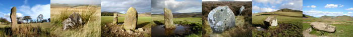
| 064
Resting Stone, Falla Moss, Tweedsmuir. |
Prev |
Next |
Description
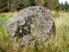
The Resting Stone appears to be a large angular boulder forming
the base of one of two cairns situated on high ground slightly
to the west of the ancient tracks running from the Devil's Beef
Tub above Moffat to Tweedsmuir. The stone measures approx. 0.90m
high and has some flat stones placed on top. The stone has also
been referred to as The Reivers' Resting Stone.
Note: It is unclear if the stone shown here is the actual
Resting Stone but has been taken as such until further evidence
is found. An alternative location for the Resting Stone is
located nearby.
Directions
From the A701 Penicuik to Moffat road, take the sign posted
junction for Tweedsmuir village. Turn first right along the single
track road heading to Fruid Reservoir. At the reservoir continue
straight on along a single track road with passing places to Fruid
farm. Park at the farm, asking for permission first. Follow the
track that skirts the top of the reservoir until you reach the
sheep pens. Cross the Carterhope Burn and keeping the burn on the
left, head for Ballaman Hill. The Resting Stone (and also
alternative site) is just south of the rock outcrops.
Note: The track shown on Explorer 330 is
indistinct and very difficult to follow. Good map reading skills
are required and a GPS device is highly recommended if visiting
the area in poor visibility.
Parking
With permission at Fruid farm.
Folklore
No written folklore or other traditions have been found
associated with this stone to date but from the stones
name and position in an isolated and often bleak location
high in the Tweedsmuir hills, it is likely to have been a
location where travellers would seek shelter during adverse
weather conditions. The ancient track which runs beside the
Resting Stone may have possible associations with cattle
rustling and the Border Reivers who were known to have used
the Devil's Beef Tub to the south as a holding area for
stolen cattle. It has also been recorded that, on still
nights, when the moon is full and casts a silvery light over
the moorland, you can hear the jingle of spurs and harness
as the ghosts of the Border Reivers drive their stolen
cattle along the ancient track as they return from south of
the Border. Could be an interesting place for an over-night
camp!
Fieldnotes
While the stone/cairns shown in the image above could be the
Resting Stone, an alternative setting can be seen about 20
metres to the south. This location comprises a large recumbent
slab surrounded by a loose scatter of smaller stones. From the
layout of the stones here, it would appear that the large slab
would have been surrounded by a low dry stone wall, providing a
sheltered place for travellers to stop and rest, hence the
Resting Stone.
|