|
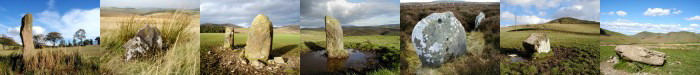
013 Stone, Caddonlee, Clovenfords. |
Prev |
Next |
Description
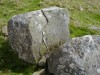
This large, flattish stone lies within the ramparts of an Iron
Age hill fort near Caddonlee Farm about 1/2 mile from
Clovenfords. Measuring approximately 1.50 x 1.50m this stone is
probably a glacial erratic and is not marked on Ordnance Survey
maps of the area. It is interesting to speculate if it had some
purpose when the fort was occupied.
Directions
From Clovenfords follow the A72 towards Peebles. After approx 1/2
mile turn left into private road leading to Caddonlee farm. The
hill fort can be seen running parallel to the main (A72) road and
the stone can be found just inside the ramparts to the north east
end.
Parking
There is limited scope for parking
near the fort, although there is space for vehicles on the verge
of the farm access road. Please
park so not to obstruct farm
traffic. Alternatively, vehicles should be left in
the village of Clovenfords 1/2 mile from the site. Take care
walking along the busy main road. There is a wide verge along both
sides for part of the route.
Fieldnotes
Though not shown on O.S. maps of the area and probably not of
any known recorded significance, the fact that this single stone
still survives within the confines of the Iron Age hill fort at
Caddonlee near Clovenfords does give pause for thought. Nearly
all the other stones in the area have been removed during field
clearance and some of these can be seen in the rampart ditch to
the south west end of the fort. Others can also be seen
littering the ground to the north west side of the fort. So,
what actually is this stone? It would be nice to think it may
have stood upright as a standing stone and has since toppled.
Perhaps it may have had an important ritual significance to the
early dwellers of the fort but only detailed archaeological
study might tells of more. In any case, it appears out of place
and to my mind at least, worthy of being recorded here.
The following year, on my way to another site, I
decided on the spur of the moment, to stop off here to get
additional pictures. The weather was crisp and bright and after
the photographs were on the bag, I started to have a closer look
at this stone. What immediately caught my eye was one of the
natural "cup" marks. On the north side of the stone a
small channel or groove had been cut, as it to drain the
"cup" mark. It does not appear natural and looks
artificial but is rather shallow and would not drain the hollow
very well. An interesting find!
|

