| 015 Coot Stone, Holylee, Walkerburn. |
Prev |
Next |
Description
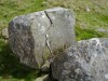
The Coot Stone is a large wedge-shaped rock, with large natural
"cup" marks on the upper surface, located a few metres
from the south bank of the River Tweed opposite Holylee to the
east of Walkerburn. The stone is actually in the river bed and
is named on O.S. Explorer Sheet 337.
Directions
The stone is accessible from both sides of the River Tweed. On the
north side, opposite Holylee, a field gate gives access to the
river. On the south side, where a closer look is to be had, take a
minor road that follows the south side of the River Tweed from
Walkerburn. When opposite Holylee, at the entrance to Elibank
& Traquair Forest, follow a rough track down towards the
river.
Parking
On the north side, a small lay-by can be found a few hundred
metres west of the entrance drive to Holylee House on the A72. On
the south side, there is parking at the entrance to Elibank &
Traquair Forest but take care not to block access to the forest.
Avoid parking if timber operations are in progress.
Folklore
No folklore to date but how the Coot Stone came to be
named as such might be worth some speculation. My theory is
that an early surveyor asked a local about the stone and if
it had a name. The local, being a canny Scot with a wry
sense of humour, saw that a Coot, a type of waterfowl, was
perched on the stone and suggested "The Coot
Stone". Just might not be so far fetched?
Fieldnotes
The stone itself certainly has little to offer, simply being a
large boulder situated a few metres away from the south bank of
the River Tweed. Having found no further information on the
stone, one can only surmise its original purpose. My best bet is
a marker stone to indicate a crossing point and Outdoor Leisure
sheet 44 indicates a Holy Well across the river on the west side
of Holylee, so perhaps, there might be some connection. One
final thought is that the Coot Stone is a boundary marker,
although placing it in the river does seems somewhat strange.
|

